
Hazleton Neighbors by Block Source
Public records can describe the land and a particular filing around a Hazleton block, but they do not form a complete neighbor roster. The strongest free starting point is the County GIS parcel layer. It shows immediately adjoining parcel shapes, PINs, a public owner field, assessed values, streets, school districts, and structure-address context. The Recorder can extend one parcel into a conveyance history. A specifically requested City zoning file can sometimes identify an owner or adjacent owner in that one file. Use each record for its documented purpose.
| Source | What It Shows About a Block | Access |
|---|---|---|
| Free County GIS | Adjacent polygons, PIN, public owner, assessed values, streets, school districts, and structure-address context. | Free map search by road, municipality, parcel, or address. No free radius tool is listed. |
| County subscription GIS | Parcel-buffer results, mailing address, deed book and page, and additional zoning, flood, soil, imagery, and map tools. | Paid County channel. The added fields remain property records, not occupancy proof. |
| Recorder of Deeds | Conveyance parties and legal-description links for a selected parcel. | Historical IQS and newer Landex routes; images or copies can cost. |
| Election Street List | Allowed voter-list fields for a documented address-related request. | Written request, identification, certification, fees, use limits, and protected-voter exclusions apply. |
| City zoning or permit file | Named applicant or owner and, in some files, adjoining-owner detail. | Defined public-record request. No broad online block search was located. |
A public owner name and a parcel beside another parcel do not prove that a person lives there. Hazleton neighbors cannot be confirmed from property ownership alone. Keep property ownership, tax correspondence, recorded parties, and household evidence separate. That is especially important on a block with multifamily buildings, vacant land, or a mailing address outside the City.
Hazleton Neighbor Parcel Start
Open the Luzerne County Public GIS Portal and search the seed address, road, municipality, or parcel. The search dropdown also accepts the County’s 17-character PIN without dashes. Record the parcel geometry, municipality, PIN, public owner field, and the street spelling exactly as displayed. A PIN can control more than one polygon, so a returned map highlight may require an extra geometry check before you decide which parcel is the seed.
Free public-layer fields include GIS PIN, land, building, and total values, PIN and long PIN, municipality code and name, export date, public owner, and public care-of. The observed free layer does not supply a complete household list, direct deed image, mailing address, or deed book and page. A mailing destination, when available from a different County channel, is a correspondence route rather than proof of who is present at the location.
- Seed parcel
- The known parcel used as the starting point for a block review.
- PIN
- The County parcel identifier that links mapped geometry to assessment and land-record research.
- Public owner
- An ownership field displayed on the free GIS layer. It does not identify all people connected to the address.
- Adjacent parcel
- A mapped polygon sharing a boundary or immediately next to the seed property. It is a map relationship, not a social relationship.
Map Hazleton Neighbor Blocks
Hazleton block research works outward from the seed parcel. The free viewer has layers, a legend, map navigation, measurement, print, and help controls. Use map browsing and measurement to inspect the polygons immediately around the seed. County guidance warns that measurement is not engineering-grade, so it is useful for orientation, not for a surveyed boundary conclusion. The resulting trail is address to parcel, parcel to PIN, then PIN to the relevant County record.
- Find the seed address in the public GIS and confirm the municipality before taking notes from nearby parcels.
- Use the map, layers, and measurement controls to inspect immediately adjoining polygons. Record each distinct PIN and public owner field with the map date.
- For one parcel’s land-history question, use the PIN and legal description to search the Recorder’s grantor-grantee route. Compare the property description before joining records.
- Use a targeted City request only for an existing permit, zoning, inspection, or code file connected to an identified property and date range.
- When the goal expands to the full record chain for a named road, use the Hazleton by-street directory rather than treating an immediate-block review as a street-wide search.
The important distinction is scale. A free GIS map supports an adjacent-parcel review. It does not offer a verified public neighborhood-radius result or transform recorded owners into a list of current neighbors.
Hazleton Neighbor GIS Records
Luzerne County separates the free public map from a subscription portal. The public map offers the parcel, public-owner, and assessed-value context needed to identify a seed parcel and its neighbors. The paid portal adds owner mailing address, deed book and page, deeded acreage, zoning, soils, LiDAR topography, FEMA flood information, multiple aerial years, select-parcel tools, drawing, swipe, and explicit radius features. Its Search By Property tool selects parcels within a chosen buffer from a parcel polygon. Notification Search selects parcels within a radius from a mapped point.
The official Luzerne Treasurer tax search provides the County’s name, parcel-number, and address search form for a defined tax-account route.
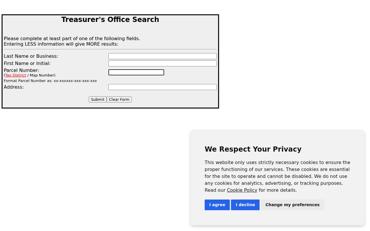
The Treasurer form requires at least one search value and accepts last name or business, optional first name or initial, parcel number, or address. The research did not capture a reliable result-card inventory, button list, or ZIP field, so those features should not be assumed. A tax record or paid GIS view can add context, but neither proves present occupancy.
Published subscription access rates are $10.58 for 24 hours, $91.88 for 30 days, and $1,008.72 for 365 days. These County figures help distinguish an optional paid mapping tool from the free public parcel layer. Check the live County page before relying on a time-sensitive price or portal condition.
Hazleton Neighbor Street Lists
Pennsylvania’s voter-registration status page is designed for personal status verification. It is not a public by-street browser. For an authorized records route, Luzerne County’s Request for Public Voter Files form lists a Street List, Walking List, Public Information Voter Listing, Voter Export, and absentee or mail-ballot listing. The form requires identification or in-office ID presentation, a written use statement, and certification.
A Street List can contain name, residence address, mailing address, party, and active or inactive status. That availability has strict statutory conditions. The form cites 25 Pa.C.S. sections 1207(b) and 1404(c)(2), plus Department regulations, and limits public-list use to election, political-activity, or law-enforcement purposes. Protected voters are excluded. Vote history can identify participation or method, never ballot selections. This is a controlled official record route, not a general neighbor-search shortcut.
Note: County voter extracts are point-in-time snapshots because the statewide SURE system is continuously updated by counties.
Hazleton Neighbor Civic Records
Community resources can provide local history and a way to verify what an organization actually does, but they are not confirmed lists of Hazleton neighbors. The research found no authoritative City directory of recognized neighborhood associations, HOA rosters, block-watch rosters, congregation membership lists, or resident contact lists. A 2021 Council discussion about why neighborhood associations had not been created reinforces that absence. Do not infer a roster from a group’s name or public events.
| Local resource | What is confirmed | What it does not supply |
|---|---|---|
| Greater Hazleton Area Civic Partnership | A Chamber-described grassroots civic organization. | A directory of neighborhood residents or member addresses. |
| Luzerne County Historical Society | Directories, maps, census indexes, newspapers, photographs, and local research assistance. | A current block contact list or universal reverse directory. |
| Greater Hazleton Historical Society | Museum, research-library, genealogy, and Church Street historic-district context. | A confirmed membership or neighborhood roster. |
The Church Street historic district covers roughly 50 blocks and 400-plus structures, making it useful historical context for a property question. It is not a directory of people. Ask the named organization about a particular historical resource rather than assuming it keeps a contact list.
Hazleton Neighbor Municipality Checks
Postal and street labels can collide across nearby jurisdictions. Luzerne County’s E-911 guidance says Hazleton City and West Hazleton Borough can both have East Shoemaker Street numbers 1 through 100. A Hazleton mailing address or a familiar road name is therefore not enough to establish which municipal record applies. Confirm the parcel’s municipality before asking for a City file or interpreting a map label.
Hazleton’s own grid is a useful secondary check. North-south streets number from Board Street, east-west streets number from Wyoming Street, and blocks north of Diamond Avenue begin at 500. The City also dedicated Ferrara Avenue in 2025 after a provisional David Avenue conflicted with David Street for 911 purposes. Keep older street names and current spellings together in research notes, then rely on the municipality and PIN to bridge the record systems.
Hazleton Block Record Comparison
Official and commercial record categories serve different purposes. A County map or Recorder index identifies defined public fields and the office responsible for them. Commercial neighbor-lookup products are compilations that may combine public and commercial data, charge for access, contain errors, or omit records. Neither category gives a complete picture of a block, and neither removes legal limits on protected information.
| Record category | Strength for Hazleton block work | Limits to keep visible |
|---|---|---|
| Official County GIS, Treasurer, and Recorder records | Named custodian, defined property or conveyance fields, and a record-specific correction path. | Property or recorded-party information does not prove every household member or current occupant. |
| Commercial neighbor compilations | May offer a broad starting suggestion for information that must be independently checked. | Potentially stale, incomplete, or incorrect; no verified custodian scope or protected-address exception. |
When a fact matters, return to the custodian that maintains the record. A defined request to the City, County, Recorder, elections office, or historical repository is more useful than expanding an unverified compilation.
Privacy Limits for Hazleton Neighbors
Public parcel and deed records do not unlock everything around a block. Hazleton neighbors may be protected by record-specific privacy rules. The free GIS layer does not expose a complete household list. Voter lists exclude protected voters and have statutory use limits. Court access leaves out sealed, expunged, juvenile, limited-access, and other protected material. PennDOT driver and vehicle data follow separate state and federal privacy rules. A no-result can reflect privacy law, a date limit, retention, or a record that belongs with another custodian.
Pennsylvania’s Address Confidentiality Program may provide qualifying participants a substitute mailing address for government, court, voter, identification, vehicle, school, and marriage records. Its purpose is safety. Do not try to infer or reconstruct a protected actual location from partial public records.
If a public property, tax, voter, business, or court record appears wrong, contact the individual custodian’s correction channel. Do not attempt to repair a record by inference from nearby parcels or a compiled listing.